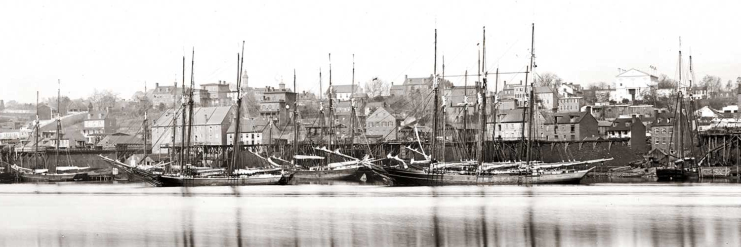
The Port of Georgetown
The First Settlers
The known history of what is now the Georgetown waterfront extends back more than 400 years, when the Anacostan Indians established the village of Tahoga on the banks of the Potomac River, near Rock Creek. The confluence of the river and Rock Creek, with a reliable supply of fish, was a central meeting and trading place for the many Native American tribes living in the region.
English explorers arrived in the early 1600’s, claiming the territory that became the Province of Maryland, and a colony of England. European settlers who followed came to the Tahoga village area on the Potomac and established a major tobacco port there, with wharves and warehouses lining the river’s edge. Officially designated in 1751 as an independent port city in the Province of Maryland, Georgetown became part of the District of Columbia upon its establishment in 1791, remaining a separate jurisdiction within the District.
An 18th Century Tobacco Port
At the northernmost navigable point on the Potomac River, Georgetown was a busy commercial port and an important mid-Atlantic trading center for tobacco. During the 18th century, nearly all the tobacco grown in Maryland and Virginia was shipped from Georgetown, making it one of the largest tobacco ports in the country. But by the end of the 18th century, tobacco exports in the area shifted to the larger ports of Alexandria and Baltimore, and activity on the Georgetown waterfront declined.
In the early 1800’s, with tobacco shipping gone, Georgetown became a transport point for grain and flour. A portion of the nearby C&O Canal was completed in the 1830’s, just north of the port along the east bank of the Potomac River, to facilitate shipping from the interior of the United States. The Aqueduct Bridge was built across the Potomac River to allow boats to “float” from the Canal to the Port of Alexandria.
19th Century Port in Decline
After the Civil War, activity in the port of Georgetown suffered further decline. Rail and highway transportation replaced water transit for trade. The “Long Bridge,” built across the Potomac at 14th St., N.W., prevented tall-masted ships from traveling up-river to Georgetown, and by the late 19th century sedimentation in the Potomac made the river unnavigable for large commercial vessels. Port activities came to an end. In 1871, Congress revoked Georgetown’s independent charter, and in 1895, Congress abolished Georgetown as a separate legal entity.
An Industrial Waterfront
Early 20th Century Development
At the beginning of the 20th century, the Georgetown waterfront experienced a rebirth as an industrial site. The old wharves and tobacco warehouses were replaced by new businesses, such as the Capital Traction Co. powerhouse, which provided power to running the electric streetcars in the District of Columbia; the American Ice Company’s large ice houses for storing ice and frozen foods; and the Brennan Construction Company, manufacture building materials for bridges and roads. During this time, tracks for the B&O railroad were built along Water Street, near the Potomac, to deliver coal to the Capital Traction Company plant. Portions of the plant’s massive concrete foundation remain today, buried beneath the lawn at the east end of the waterfront park.
In 1923, Francis Scott Key Bridge, at the west end of Georgetown, was completed, and in 1933 the Aqueduct Bridge, which had been converted for vehicular traffic, was demolished. A remnant of the stone embankment remains along the shore. Over the next decade, most of the factories moved to the suburbs, or went out of business, leaving large vacant buildings along the waterfront. Some of the old buildings were converted to house flour and paper mills, a bottling company, and a rendering plant. The waterfront became increasingly unkempt and soon was known for its odorous rendering plant.
A Blighted Waterfront
In 1949, Washington’s first elevated highway, the Whitehurst Freeway, was built over Water Street near the Georgetown waterfront. The new freeway served as a visual barrier between the industrial buildings on the Georgetown waterfront and the historic village to the north.
In the 1950’s, the District of Columbia planned to build two inner-loop freeways to funnel traffic around and through the central city. Through condemnation, the District acquired 10 acres of privately-owned land along the Georgetown waterfront for one of the freeways. Over time, strong public opposition to the inner-loop freeway project caused the District to abandon the project in 1977. By law, the condemned land could be used only for transportation or parks, so for many years the District used the Georgetown waterfront land as a parking lot and for storing trash trucks and road salt.

